
In partnership with Muon Space and Google Research, the Alliance unveils breakthrough wildfire imagery, signaling a new era of precision, data, and insights for fire response 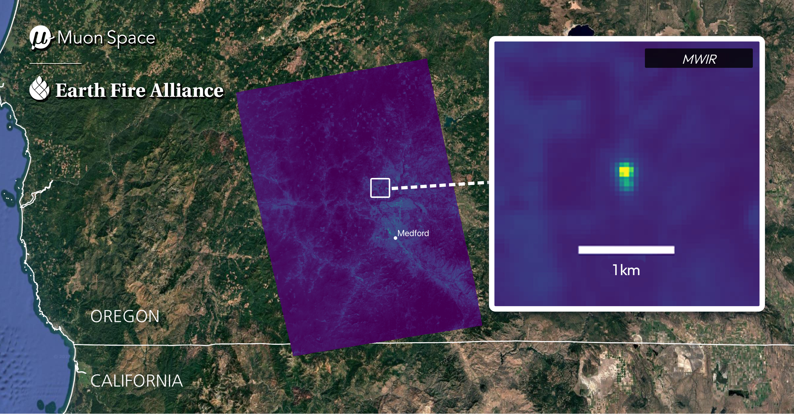
SAN FRANCISCO--(BUSINESS WIRE)--Earth Fire Alliance, the global nonprofit coalition committed to delivering transformative data and insights from all wildfires on Earth, in collaboration with Muon Space and Google Research, today released the first wildfire images captured by the FireSat Protoflight satellite. Collectively, these images demonstrate the powerful impact FireSat will have on communities and the firefighters who protect them worldwide.
Among the first images is a small fire in Oregon, USA, that was undetected by existing satellites, highlighting the opportunity FireSat presents to deliver insights missed by other space-based systems and to help first responders identify more fires in their early stages, assess their potential impact, and act before the fires escalate into public safety threats.
FireSat can detect fires as small as 5x5 meters, making it orders of magnitude more precise than existing satellites. Once fully operational, the FireSat constellation will scan Earth’s most fire-prone regions every 20 minutes, enabling unprecedented detection, monitoring, and characterization.
The image collection spans diverse fire conditions across North America and Australia:
- Oregon, USA: A small roadside fire undetected by existing space-based systems was identified by FireSat, showcasing the satellite's superior sensitivity for early-stage fire detection.
- Nipigon 6 Fire, Ontario, Canada: FireSat's multispectral sensor distinguishes active fire regions from land that has experienced prior fires and unaffected areas.
- Northern Territory, Australia: FireSat detected multiple active fires and revealed variations in surface temperatures across the landscape.
- Moran Fire and Chicken Fire, Alaska, USA: This capture of two fires in one image demonstrates FireSat's value for monitoring remote regions where it is challenging to conduct ground-based observation.
“These images represent a turning point in how the world will see and respond to wildfires," said Brian Collins, Executive Director of Earth Fire Alliance. "FireSat is the result of extensive collaboration among engineers, researchers, frontline fire agencies, and philanthropies—and it's built to serve fire agencies around the world. Our goal is simple: ensure that every fire, anywhere on Earth, is visible and understood in near real time.”
Next-Generation Infrared Sensing
FireSat was purpose-built for the global wildfire challenge. Informed by close coordination with hundreds of national, regional, and local fire officials, as well as fire modelers and scientists, the satellite’s advanced multispectral infrared sensors, designed and built by Muon Space, meet their real-world needs. FireSat can sense through smoke and clouds to reveal small fires and measure critical metrics such as fire perimeter, progression, and intensity.
“These first images are a powerful demonstration of what we built FireSat to do,” said Jonny Dyer, CEO of Muon Space. “We’re seeing clear, actionable detection of wildfire activity across multiple regions, which will provide an invaluable tool for first responders. While early detection is important, what’s equally critical is FireSat’s ability to support ongoing fire management by tracking a fire’s progression and behavior.”
Operating in low Earth orbit, FireSat has a 1,500 km observation swath and a ground sample distance of 50 meters from directly overhead. Its combination of resolution, thermal sensitivity, and broad dynamic range allows it to sense small, smoldering fires while simultaneously monitoring extreme wildfire events.
A World-Class Wildfire Dataset
Building on the successful Protoflight launched in March, Earth Fire Alliance and Muon Space will deploy the first three operational FireSats in mid-2026, which will deliver twice-daily global observation. The full constellation will comprise 50+ satellites by 2030.
Google Research plans to use AI to compare operational FireSat data with historical images of the same location, then take local weather and other factors into account to identify small fires with low false positive rates. AI applications will also reveal insights on fire behavior for predictive modeling.
"Paired with advanced AI, this data will be invaluable for fire authorities and Earth science," said Chris Van Arsdale, Google Research Climate & Energy Lead and Chair of the Earth Fire Alliance Board of Directors. “FireSat’s first wildfire images are precisely what we envisioned when we began this research and partnership."
The Power of a Global Coalition
Projections show that the FireSat constellation will deliver significant public safety, economic, and environmental benefits. In the United States alone, even a one-hour FireSat revisit rate could annually save more than $1 billion in fire damage costs, protect 3,500 homes and properties, reduce burned land by 1.3 million acres, and prevent 21.9 million tons of carbon emissions.
In June, Earth Fire Alliance announced the first cohort of participants in its Early Adopter Program, which offers an opportunity for fire agencies and fire scientists to help refine data products, define data delivery mechanisms, and harness the potential for FireSat data when initial operational capability is reached in 2026.
Earth Fire Alliance is grateful to founding partners Google, the Gordon and Betty Moore Foundation, Environmental Defense Fund, Muon Space, and others that have contributed scientific expertise, leadership, and philanthropic support to make the FireSat program possible. The inaugural FireSat images represent a milestone in leveraging public-private-philanthropic partnerships to advance global wildfire detection, response, and understanding.
To access all four images in high-resolution, please visit: https://www.earthfirealliance.org/press-release/firesat-first-wildfire-images
About Earth Fire Alliance
Earth Fire Alliance is a California Nonprofit Public Benefit Corporation founded in 2024 on the belief that high-fidelity data, accessible on a global scale, will transform humanity's collective approach and relationship to fire. The Alliance shares a vision of expanding wildfire focus and funding from reactive suppression to proactive stewardship that includes better informed real-time decisions on the ground, data-driven resilience initiatives, and improved understanding about the positive and negative role of fire on the landscape. Committed to delivering transformative real-time data from all wildfires on Earth through user-driven technology and radical collaboration, Earth Fire Alliance champions the FireSat constellation. For more information, visit earthfirealliance.org.
Contacts
Earth Fire Alliance Media Contact: Kristin Cody, Earth Fire Alliance, press@earthfirealliance.org